Vietnam climate intelligenceHigh-resolution weather + energy forecasting

Climate ICT convergence for operational decisions

Your path to climate intelligence.

Control F combines meteorological expertise, AI and big data, 3D GIS, and custom delivery channels to turn high-resolution weather data into practical decision support.

Resolution
3 km to 500 m
Coverage
Vietnam GIS layers
Delivery
Dashboard / API / reports

Control F

Climate ICT that turnsweather data intopractical decisions.

Control F combines meteorology, AI & big data, 3D GIS, and custom delivery systems to provide high-resolution weather intelligence through dashboards, APIs, reports, and applied services.

MeteorologyAI & Big Data3D GISService Delivery
Core input
Weather data + GIS context
Applied engines
WIBIS / CF-AIM / simulation
Delivery
Dashboard / API / report

Weather Intelligence Production

What is VHWIS?

Vietnam High-Resolution Weather Intelligence System

VHWIS is high-resolution weather data intelligence for Vietnam. It localizes weather intelligence for each industry and operating site.

By combining meteorology, terrain, GIS layers, and local context, VHWIS turns weather data into intelligence that can be applied on the ground.

High-Resolution Data

Produces detailed weather intelligence from forecast, observation, terrain, and GIS datasets.

Vietnam Localization

Adapts outputs to Vietnam’s terrain, climate, coastal regions, cities, and operating conditions.

Industry Application

Applies weather intelligence to energy, logistics, ports, smart farms, urban operations, and other local industries.

Production Pipeline

How VHWIS works

VHWIS transforms diverse weather data into high-resolution weather intelligence through a streamlined production pipeline.

01

Source Data

Forecast models, observations, terrain, GIS, and local reference data.

02

Processing

Quality control, downscaling, data fusion, and spatial refinement.

03

Intelligence

Forecast layers, risk layers, time-series outputs, and operational datasets.

04

Applications

Visualization dashboard, ENERMICS, API/report delivery, and 3D simulation.

VHWIS Visualization Interface

VHWIS VisualizationInterface

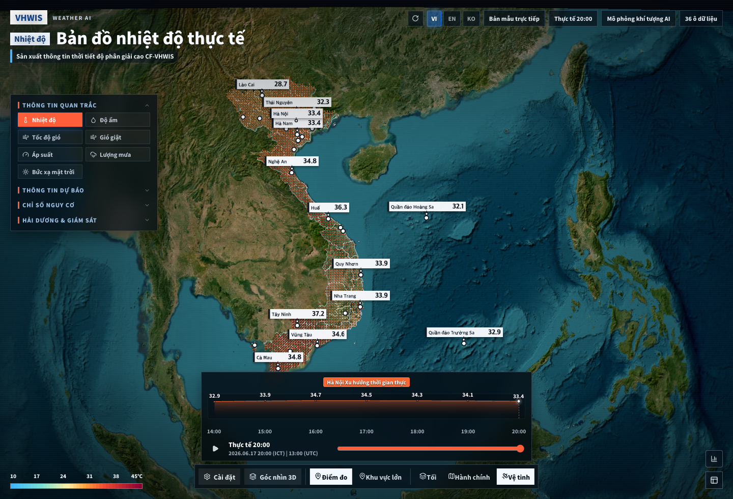
VHWIS high-resolution Vietnam weather map interface

Interface for VHWIS-produced weather intelligence.

The VHWIS interface visualizes high-resolution weather intelligence produced by the VHWIS platform, including weather variables, risk layers, timelines, and regional map views for Vietnam operations.

Mode
3D / 2D GIS
Region
Vietnam
Output
Weather + risk layers
Open VHWIS Platform

Weather Layer Review

Temperature, rainfall, wind, humidity, solar radiation, AQI, and domain layers are organized for map-based operational review.

Risk Monitoring

Operational boards help teams review tropical cyclone paths, live status, and high-impact weather signals.

3D GIS Operation View

Oblique map states, timelines, and station views support a weather-simulation command surface.

Applied Weather Intelligence

From VHWIS to ENERMICS

High-resolution weather intelligence becomes energy forecasting intelligence.

Renewable energy forecasting depends on accurate local weather information. By producing high-resolution weather intelligence for Vietnam, VHWIS provides the meteorological foundation for applying ENERMICS to solar and wind energy forecasting.

VHWIS weather intelligence
ENERMICS AI forecasting
Renewable energy operation support
ENERMICS

Environment and EnergyMeteorological InformationConvergence Solution

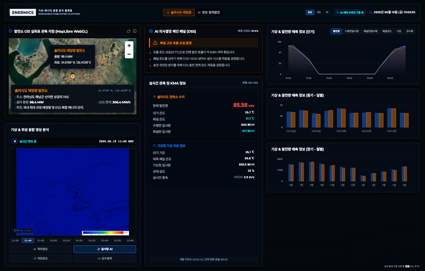
ENERMICS renewable energy forecasting dashboard interface

Renewable-energy generation forecasting and operation support.

ENERMICS combines high-resolution weather data and AI machine-learning models to forecast renewable-energy output and support bidding, monitoring, and operation planning.

Assets
Solar + wind
Engine
Weather + AI
Use
Forecast / bid / monitor
Open ENERMICS Platform

Generation Forecasting

Plant-level weather forecasts and machine-learning models estimate renewable-energy output by location.

Operation Dashboard

Live generation status and weather trends are composed into a user-facing monitoring dashboard.

Planning Support

Forecasted generation data supports power-market bidding, facility operation planning, and routine reporting.

Solar asset intelligence

Solar generation forecast context

Wind asset intelligence

Wind power operation context

3D GIS / UE5 Extension

Weather intelligenceas immersivespatial simulation.

Control F is also developing 3D GIS and Unreal Engine-based simulation technology to visualize weather conditions, risk scenarios, and operational environments in immersive spatial contexts.

3D GIS and Unreal Engine simulationSpatial extension of VHWIS data
ctrl-f.co.kr

Smart City Climate Operation

Urban-scale weather intelligence between platform and field operation.

A visual checkpoint for city-scale climate monitoring, 3D GIS interpretation, and operational weather context.

How it works

Weather data becomesoperationalintelligence.

Control F starts with specialized weather and climate data, processes it through WIBIS quality control, maps AI models through CF-AIM, and delivers results through dashboards, APIs, reports, or enterprise integrations.

01

Meteorological Data Collection

Collect KIM, LDAPS, RDAPS, forecasts, warnings, observations, datasets, and domain reports through source data and APIs.

02

WIBIS Processing & QC

Validate data, improve spatial resolution, and prepare operational grids using Control F methods including CF-CALMET and CF-PRIZM.

03

Applied Data Production

Generate applied weather information, build time-series databases, and organize the output for service delivery.

04

CF-AIM Model Mapping

Map ML/DL models such as CNN, LSTM, and Random Forest to industry-specific forecast, detection, and risk problems.

Company Overview

A meteorology and ICT convergence company built for practical weather-risk decisions.

Founded2020.01.02
HeadquartersDaejeon, Republic of Korea
Core businessICT convergence, AI and big data, meteorology, solution integration
Delivery modelSaaS/API, system integration, expert consulting

Climate Risk Quantification

Translate uncertain weather into measurable operational and financial risk for clearer decision-making.

Industry-Specific Platforms

Apply weather intelligence to renewable energy, logistics, ports, smart farms, aviation, marine safety, and urban climate analysis.

Vietnam Partner Context

The company deck lists Vietnam partner references including Binh Duong, Ho Chi Minh City, and national water-resource planning organizations.

Solution Portfolio

Additional meteorologicalconvergencesolutions.

iomics

IOMICS

Intelligent Ocean Meteorology Information Convergence Solution. Supports marine operations with detailed ocean-weather forecasts, visual maps, APIs, and alerts.

famics

FAMICS

Farming industry Meteorological Information Convergence Solution. Combines weather, growth data, and AI to support production, management, and safety in agriculture.

ivias

IVIAS

Artificial Intelligence sea Fog Image analysis Detection Solution using CCTV. Uses coastal CCTV imagery and neural-network analysis to detect sea fog and support alerts.

lomics

LOMICS

Logistics Optimization Meteorological Information Convergence Solution. Combines high-resolution weather and logistics data for route-risk prediction and operation planning.

Control F Vietnam

Build practical decisionsfrom high-resolutionweather intelligence.

Control F provides custom climate ICT services from consulting and system design to deployment through web, application, API, file, and dashboard channels.